Data Connectors
What are MTK Data Connectors?
Say you already have a search solution that works well but only outputs results as a list. Maybe it includes basic map views, but they lack detail and interactivity. You want to go further. You want to display your data using full vector cartography. You want to automatically add static maps, elevation profiles, and other geospatial metadata. You want the ability to visualize thousands or even tens of thousands of geodata points on a map, all while continuing to use your existing filtering and full-text search capabilities. And you want it to be fast and seamless.
This is exactly what Maptoolkit Data Connectors provide. They add a fully featured vector map output to your existing search system. You keep the strengths of your current setup, while Maptoolkit brings scalable map rendering and automatic data enhancement. The integration process is quick and typically completed in just a few minutes.
Data Connectors are a feature for Maptoolkit Enterprise customers. For details, see Maptoolkit Pricing.
What technologies do MTK Data Connectors work with?
Maptoolkit Data Connectors can be used with most systems, as long as there is a structured, URL-based interface that outputs your geodata. Once that’s in place, Maptoolkit handles everything else. Caching, vector tile generation, and metadata enrichment all happen automatically on Maptoolkit servers.

This is how MTK Data Connectors work
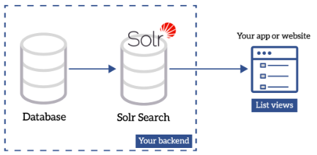
Imagine a setup like the following, with a Solr server (or similar technology) outputting data based on filters and/or fulltext search:
Setup without MTK Data Connector:

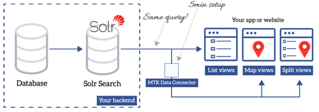
With a one-time setup, typically completed in just a few minutes, you can add a vector tile map view to your existing list interface. There’s no need to worry about scaling or performance, as Maptoolkit automatically mirrors and caches your geodata, making it possible to display tens of thousands of items smoothly. Metadata such as elevation, distance, elevation profiles, and static maps is generated automatically. Your existing filtering and full-text search functionality remains unchanged. The same query URLs and parameters continue to work as before. All you need to do is customize the look and feel to match your application.
Setup with MTK Data Connector:

Our Pricing Model

Flexible pricing that scales with you.
Start with our free tier, pay per request on RapidAPI as you grow, or choose an Enterprise license for full access.
FAQ
Yes, there is also a way to trigger updates when data is changed in your system.
Since the data is mirrored, it follows the pattern of your implementation.
The Data Connectors support standard authentication methods (like BasicAuth).
Yes, the Data Connector supports all kinds of geodata.
There are predefined connectors for Solr, PostgreSQL, GeoJSON. Besides those, there is also the possibility to create a custom connector using JavaScript.
We’re here to help

My name is Peter Höflehner and I will be your
project- and key account manager.


